Where?
ReAnglia’s work is rooted in Anglia, drawing on its particular heritage and ecology, whilst also operating at the level of worldview, governance and imagination.
Like its coastline which has always been in relationship with the ebb and flow of water, Anglia is not a permanently defined area. For most of human history, people organised themselves around watersheds, geological landscapes and ecosystems. It’s how sustainable cultures lived – knowing their watershed as intimately as family, knowing how to live well there for generations. Loosely, the region could be described by its rivers – all flowing into the North Sea between the northern coast of the Wash and the southernmost Essex estuary north of the Thames.
Anglia was chosen because:
- Practically, this is where we stand – Jenni, the founder, lives here and has heritage here.
- There is a lack of regenerative futures work based on ancient nature-connected wisdom in this region. It is no coincidence that nature-led regenerative futures work is flourishing in parts of the UK – Wales, Cornwall, the South West – where the Roman occupation took less hold and where threads of Brythonic language and culture survived. In Anglia the severance of pre-Roman heritage and forgetting of kinship with the land was more thorough and has been compounded by draining of the fens, enclosure, industrial agriculture and modern industry. This is where this work feels most needed.
- At the same time, there is much aligned work already happening across the region — in land stewardship, ecological restoration, community organising and place-based learning. ReAnglia seeks to complement and champion this: offering a space for the worldview and governance questions that underpin it, serving as a connector of people and initiatives who share the deeper why, and a hub around which new approaches for this region can coalesce.
Anglia – Landscape
Anglia’s main rivers include the Great Ouse, Nene, Welland, Witham, Stour, and Waveney, each draining different parts of the region and shaping distinctive lowland and fenland landscapes. All land throughout the region is part of a river’s watershed. The rain that falls on homes, fields or streets travels through soils, ditches and underground aquifers into the nearest stream, river and ultimately the sea. Beneath our feet, underground aquifers collect, store, and slowly release groundwater vital to all life. Wherever you live in Anglia, you live within and depend on a watershed.
Anglia’s water systems connect a varied mosaic of landscape. In the North lie the rich wetlands of the Norfolk Broads and the vast drained peatlands of the Fens. In the centre, the unique heathlands of the Brecklands and many wooded river valleys. In the East, the estuaries, marshes, sandy heathlands and coastal plains. In the South, the threatened chalk streams that spring from the chalk and limestone uplands and the Greensand Ridge of heath grassland and wood pasture. In the West, rolling clay and limestone landscapes and the ancient woodlands of the Chilterns and Rockingham Forest. These diverse landscapes support some of the richest wetland wildlife in the UK, alongside highly productive farmland – sometimes called ‘the breadbasket of the UK’ – creating deep interdependence between communities, food systems and the health of soils, rivers and aquifers.
Anglia – Name
“Anglia” is a pagan name that takes its name from the Angles, a Germanic people who arrived from the Angeln peninsula (modern Germany and Denmark) in the 5th century. Strangely, the Angeln peninsula itself is a rounded, shoulder-like promontory not dissimilar to the Anglian peninsula. The name Angle is thought to mean hook – which may refer either to the shape of the peninsula or the fishing hooks used by its peoples. Historically, “Anglia” and “Engla land” were used for the whole of England, not just the eastern region. While ‘East Anglia’ originally referred to present day Norfolk and Suffolk, is now commonly used to include Cambridgeshire and Essex. The name Anglia is used (for example by ITV Anglia and the UK’s Anglian River Basin District) to variously extend to all or part of Northamptonshire, Rutland, Bedfordshire, Hertfordshire, Buckinghamshire, Lincolnshire and Leicestershire. So, while contemporary “Anglia” has no single agreed definition and has never been a neat, fixed thing, it no longer refers to the whole of England but as a regional descriptor (e.g. by Anglia Ruskin University, Greater Anglia Railways, Anglia Television and Anglian Water). The region does not have a strong unified identity – Cambridge and Essex often look south toward London, Norfolk and Suffolk often feel culturally distanced from Cambridgeshire. North and South Cambridgeshire have significant cultural divides, and the Fens and Peterborough feel distinctive to themselves, with the north south and western fringes of Anglia maybe feeling more part of the Humber, Midlands or Thames regions.
Anglia – Character
While the region doesn’t form a coherent whole, what unifies it and distinguishes it, compared to the rest of the British Isles, is the many variations of earth-water relationships, with a depth of cultural and geological meaning. The promontory is glacially formed — built up, deposited and rounded by glacial deposition, soft, accumulated land pushed out toward the sea, impermanent and easily eroded, with one of the fastest-eroding coastlines in Europe. The land is not a fixed backdrop but an active participant in the landscape’s story.
🌀The Broads and Fens are not merely wetland but land reclaimed from water, continuously negotiated with drainage, and with an extremely distinctive cultural history.
🌀Modern day Norfolk was isolated from the rest of the country by a marsh barrier when Roman drainage works failed, allowing its people, the marsh-dwelling Gyrwas (possibly of Celtic origin) to maintain independence from the Anglo-Saxon kingdoms and preserve their identity.
🌀When wealthy landowners brought in a Dutch engineer to drain the fens for farmland, the Fen Tigers – communities depending on the wetlands for fishing, fowling, eeling and reed-cutting – fought to keep their watery home.
🌀The chalk streams, of which this region has one of the highest concentrations in the world (England has 85% of the world’s chalk streams and nearly a third of those are here), represent a different kind of interface: the chalk filters and releases water which has passed through the rock over time, in conversation with the earth.
🌀Along the Suffolk and Essex coast, there are “nesses” — shifting shingle promontories built up by longshore drift, which continue to migrate by metres per year, constantly reshaping the eastern edge of the region. Here, the land doesn’t end but dissolves into estuaries, lagoons, mudflats and saltmarshes — liminal terrain where the threshold between land and sea is a process, not a line.
The liminal quality of the landscape mirrors the liminal quality of the work ReAnglia does: standing at the threshold between paradigms, between past and future, between separation and kinship. The physical character of land that is always in conversation with water gives us a frame for how we can be in conversation with both.
Anglia – Pressures
Anglia’s complex wetlands, peatlands and river corridors have been shaped by human activity for millennia but have also suffered significant degradation. The Roman conquest followed centuries later by large-scale fenland drainage transformed vast wetland commons into farmed fields, often depriving local communities of their traditional livelihoods and breaking deep-rooted cultural relationships with the land. This legacy has caused severe habitat loss, soil degradation, peat carbon release and fragmentation of wild landscapes.
Today, the Anglian basin faces major ecological pressures: water stress from over-abstraction, nutrient pollution from intensive agriculture, coastal erosion and threats to its globally rare chalk streams. Infrastructure and development pressures are mounting from expanding ports, logistics hubs, urban growth, and biotechnological industries, alongside rising housing demand.
Anglia – Heritage
Many cultures view time as layered rather than linear – the past, present, and future are connected, cyclical, and influence each other. The past is still alive in the present, the future is here now. The people of this land are all the peoples living in relationship with these watersheds from all times – past, present, and future. This includes the more-than-human life – the rivers, fens, woodlands and creatures. This region carries three distinct layers of ‘pagan’ nature-connected heritage – where three sacred traditions of earth-belonging converged and were then buried together…
Brythonic (Celtic) (Iron Age): Before the Romans arrived in CE 43, Anglia was inhabited by Brythonic/Brittonic (deriving from Pritani) peoples including the Iceni, Trinovantes, Catuvellauni and Corieltauvi/Coritani. These communities lived in reciprocal relationship with their rivers, wetlands, woodlands and heaths, guided by spiritual and practical respect for the land, seasonal cycles and collective stewardship. It is likely that they held a kinship worldview. Brythonic heritage was severed by Roman conquest probably more thoroughly than most parts of Britain — Cornwall and Wales retained threads of Brythonic heritage through language continuity; Anglia did not. This makes the recovery work both more urgent and more needed here.
Anglo-Saxon/Germanic (5th–9th century) The Angles brought their Nerthus (Mother Earth) worship, sacred grove traditions, and Germanic cosmology to this region and practiced until the arrival of Christianity in the early 7th century, likely maintaining their folk practices much longer.
Viking/Norse/Danish (9th–11th century): East Anglia was specifically targeted by the Great Heathen Army in 865. Guthrum settled here after his treaty with Alfred and created the Kingdom of Guthrum. The Norse brought Yggdrasil (the world tree), the Thing (assembly/council tradition), and crucially: the word law itself in English derives from Old Norse, brought here by the Danes of the Danelaw.
Although much of this wisdom was eroded by later conquest and transformation, it inspires how we can live today: combining relational, place-based understanding with modern scientific and technological capabilities. Re-imagining our connection to nature means drawing on the strengths of both ancestral practice and contemporary innovation, enabling communities to flourish in partnership with the Earth rather than apart from it.
This land has seen many peoples. Mesolithic hunter-gatherers, Brittonic tribes, Romans, Anglo-Saxons, Vikings and countless others. These are ancestors of place, not gatekeepers. All who live here can be in reciprocal relationship with this land – shaping and being shaped by this place. Wherever our ancestors were born, they were at some point in relationship with nature. Many who live here now carry traditions of reciprocal relationship with nature from other parts of the world. These perspectives enrich and deepen our collective understanding. We are all of this Earth and this understanding is our birthright.
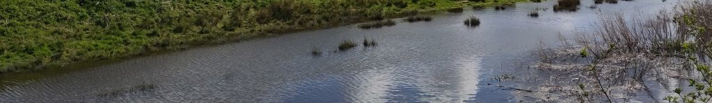
Photo by J. Ramos – Old Bedford River from Welney WWT.
ReAnglia CIC (Company No. 17185336)